 SWRainAlert
SWPPP inspectors
Stop watching the sky and refreshing a weather app between site visits. The rolling 24-hour total, the permit threshold, and the clock are all in one screen — with the form already open to the storm that triggered it.
Built for SWPPP inspectors & general contractors
SWRainAlert watches NOAA rainfall over every site on your permit and tells the person who has to act — inspector, super, or compliance manager — the moment a storm crosses the trigger, with the deadline already counted in the site's own local time.
No credit card. Continental US coverage · Permit thresholds verified in GA, TX, FL, NC and TN · Forecast warnings from the National Weather Service.
Rolling 24 h accumulationThreshold 0.50″
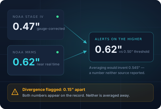
Sources disagree by 0.15″. Both are on the record; the alert used the higher.
On Stage IV alone this storm never crossed 0.50″. Running one source, nobody gets told to inspect.
Built for the people who answer for the storm
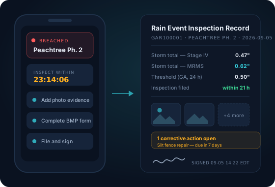
The inspector has to be there within the window. The super has to know before the regulator does. The compliance manager has to prove all of it happened, months later, across every site on the permit. SWRainAlert gives each of them the same storm, in the view their job actually needs.
Stop watching the sky and refreshing a weather app between site visits. The rolling 24-hour total, the permit threshold, and the clock are all in one screen — with the form already open to the storm that triggered it.
You are the one the fine gets addressed to. Get the same alert your inspector gets, across every site your crews are running, so a missed inspection is never the first you hear of a storm.
Run the portfolio, not one site at a time. See every open item ranked by how overdue it is, and export a signed, unalterable record when an auditor — or a regulator — asks for one.
Why this exists
Federal stormwater penalties run to five figures per day, per violation, and the storm that causes one is rarely the one anyone was watching. It's the second storm that afternoon, or the one that landed while the super was driving between jobs and the inspector was on a different site entirely.
Most tools accumulate against a calendar day. Two separate storms look like one, the second one never re-triggers, and nobody inspects. We close a rain event after six dry hours so the next storm starts from zero.
A Georgia site evaluated in UTC lands four to five hours off. Inside a 24-hour window that moves the deadline to the wrong day. Every deadline here is computed in the site's own timezone, and a site without one is refused at creation.
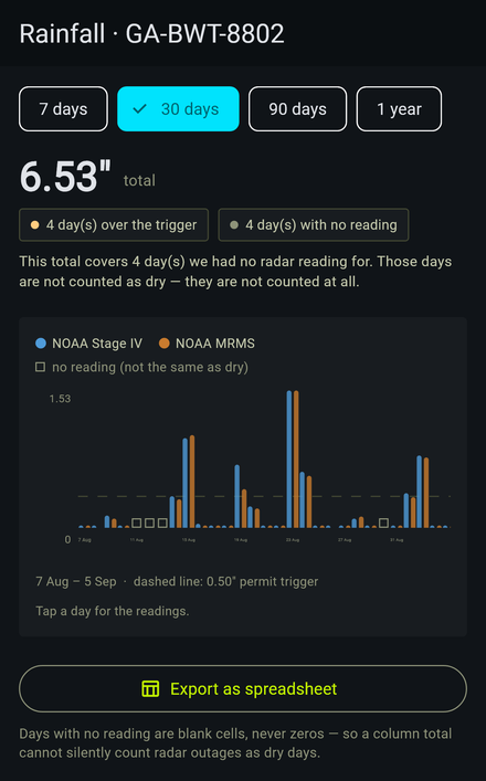
Radar gaps carry sentinel values. Treated carelessly they become 0.0 — and a site the radar could not see looks exactly like a site where it did not rain. We render those as unavailable, never as zero.
Differentiator 01
Everyone in this market says "synced with NOAA." Nobody runs two independent products side by side and shows you the readings when they disagree.
The rain event, start to finish
The evaluator runs every five minutes. Notification decisions ride on the event's own flags — never on "did the number change since the last poll" — so a storm sends one alert, not twelve.
The rule that matters most
Accumulation is measured on a rolling window, not against midnight. A storm that starts at 22:00 and runs to 02:00 is one storm, and it is measured as one.
Then the event closes. Six hours with no accumulation ends it, the inspection clock for that event stops, and the next storm builds its own total, sends its own alert and gets its own deadline.
Honest about the edge: a storm that clears the threshold in a single reading never passes through APPROACHING. It goes straight to BREACHED, and the alert goes out on that transition.
Differentiator 02
Our ground is the rules: which requirements this storm triggered under this permit, what deadlines follow, and which corrective-action clocks are now running. Where we look at a photograph, it drafts a finding for a person to accept — it never files one, and it never decides whether a site is compliant.
Differentiator 03
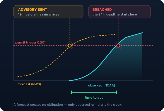
Observed rainfall tells you an inspection is now due. A forecast tells you to stabilise the slope, empty the basin or move the crew while there is still time to do any of it.
A forecast creates no obligation. Your permit triggers on rain that fell. The inspection clock starts on an observed reading, never on a prediction, and we keep the two in separate records so a forecast that missed can never look like a storm that happened.
See it before you sign up
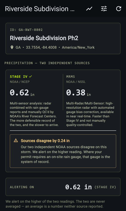
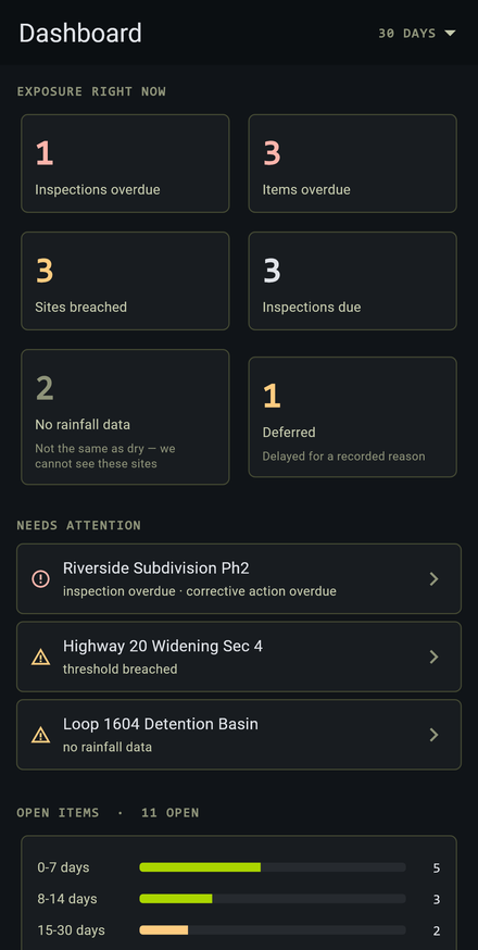
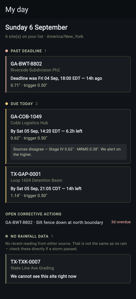
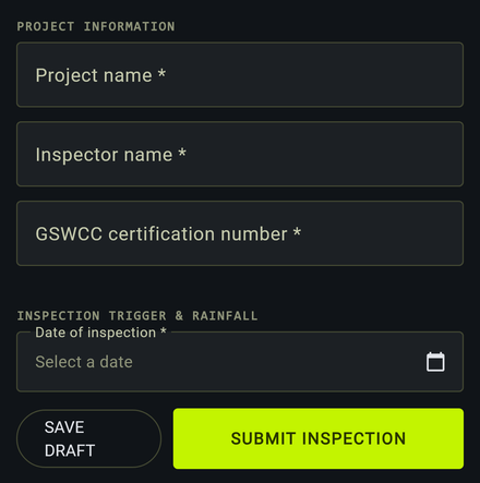
Eight real screens from the Android client, not mockups drawn to sell you something. It plays itself below — or tap any label and step through it yourself.
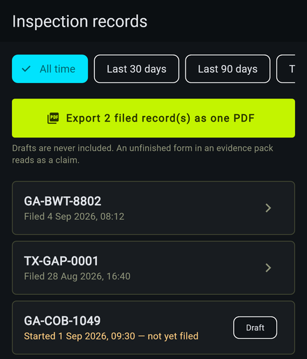
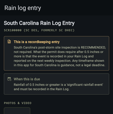
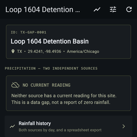
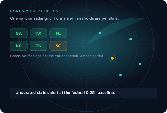
Coverage
The threshold that triggers your inspection is set by your state's construction general permit, and permits expire. Reading two permit eras as concurrent rules is the standard way this gets wrong — it is how a "dual trigger" that never existed ends up in a product.
So every threshold we ship is checked against the primary permit text, with its effective and expiry dates, and the ones we have not fully confirmed are labelled as such rather than presented as fact.
VerifiedGAR100001, effective 2023-08-01, expires 2028-07-31. Checked against the primary permit text.
Shipped defaults, not legal advice. Your permit or a Sensitive Waters designation can be stricter; every threshold is editable per site.
How we differ
You're the one who has to defend this system to an auditor. Five questions worth asking any rainfall alerting vendor before you sign — including us.
| The question | Typical answer | SWRainAlert |
|---|---|---|
| How many rainfall sources? | One, described as "NOAA data" | Two independent NOAA products, both stored, alert on the higher ✓ |
| What do you show me when sources disagree? | Nothing — there is only one number | Both readings and the divergence, on screen and on the report ✓ |
| What happens on the second storm of the day? | Often nothing; accumulation runs to midnight | Six dry hours close the event; storm two alerts on its own ✓ |
| What do you do when the radar can't see my site? | Reports 0.00″ | Reports unavailable. A gap is never rendered as dry ✓ |
| Where did your state threshold come from? | Unstated | Named permit, with effective and expiry dates, and a verification status ✓ |
"Typical answer" describes patterns we have observed in publicly available marketing and documentation across this category. Ask your current vendor directly — the answers are the point, not our summary of them.
Questions
No. Where your permit names an on-site gauge as the system of record, the gauge is the record. SWRainAlert is a monitoring and recordkeeping aid: it tells you when to go look, and keeps a defensible trail of what NOAA reported. We say this in the app, not buried in terms — inspectors know the rules better than we do.
Two independent NOAA products. Stage IV is the multi-sensor analysis quality-controlled by the River Forecast Centers — slower to arrive, and the defensible record. MRMS is NSSL's radar analysis with automated gauge bias correction, near real time. Both are stored per site, per source. We alert on the higher and flag any divergence.
After six hours with no accumulation the rain event closes. The next storm accumulates from zero and gets its own alert, its own threshold evaluation and its own inspection deadline.
The evaluator runs every five minutes. You get one notification per event per transition — a storm that breaches once sends one breach alert, no matter how many times it is re-evaluated while it rains.
Rainfall alerting covers the continental United States. Permit thresholds and inspection forms are curated state by state: Georgia, Texas, Florida, North Carolina and Tennessee are verified against the current construction general permit; South Carolina and Alabama are marked partial, with the reason given. Uncurated states fall back to the federal 0.25″ baseline.
You are blocked from creating new sites until you upgrade. You are never blocked from reading your data, receiving alerts, editing a threshold or retrieving a filed inspection. A billing state should never cost someone access to their own compliance record.
Both. The inspection trigger is observed rainfall from two NOAA products, because that is what your permit is written against. Separately, we read the National Weather Service forecast for each site and send an advance advisory when the forecast reaches that site’s trigger within 24 hours, plus any active rain-relevant NWS alerts. The forecast creates no obligation — it buys you time to prepare.
Yes. Scoped API keys give read-only or read-write access, and outbound webhooks push breach, forecast advisory, weather alert and inspection events to your endpoint, signed with HMAC so you can verify they came from us. The API documentation covers both, and the sandbox lets you try the rainfall logic before you have an account.
Yes. The mobile app paints your cached fleet before it tries the network, queues inspections and photos in a write outbox, and always tells you how old the cached data is.
Thirty days of the Complete plan, every feature, no card. Add your sites by address or by dropping a pin, and the inspector, the super and the compliance file are all covered before the first drop lands.